March Will Roll In Like An Angry Lion


They say March comes in like a lion and goes out like a lamb or the other way around. Well the bar has been set, she is getting it all in the beginning of this month, like a pride of angry lions. We are starting off March first, tomorrow, with a big nor’easter like storm. Coastal flood watch, High wind watch and almost a dozen other “issues”. You know the drill if you live here we are used to this, but just in case you aren’t. Welcome to the nor’easter like storms of Delaware at the beach, that at times have been worse than hurricanes. Plan on the staying indoors, the movies, or a lot of crowded outlet shopping.

This storm will be rough on the beaches, and once she passes, we will still be dealing with heavy waves into Tuesday predicted up to eleven feet. The beaches will get carved up and have a few drop offs for sure. it is possible parks will close drive on access. You would have to be a damn fool to drive out onto a beach in this weather. Yes, been there done that, it can be a tad hairy. Best not to chance it honestly. I am sure the surfers might try for some killer, literally, waves.
Beach combing will be stellar on Sunday, but the waves will be heavy into Tuesday. There will be swales (tide pools) carved onto the backside of the beaches, be careful that sand can be a little “quick” in places. Do not drive through them I can not stress that enough,but if you do send us a picture of your vehicle sunk to its frame. These swales will cut through the beach and create stream like drains back into the surf. After this storm will be a good time to read the beach for really defined cuts for good fishing spots.

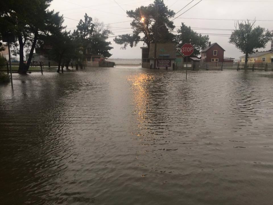
Thursday will start out windy and rain, the real fun will crank up Friday morning with heavy winds gusting up to fifty knots and all the watches go into affect. I doubt we will see any dune breaches, but you never know. High tide is when that is the biggest issue. If the winds are heavy and in the right direction then it can happen. All it takes is a high tide with heavy storm surge, pushed by fierce winds to breach a dune and flood route 1. The good news is westerly winds to start, but will switch to north winds. All it takes is a little easterly push to create an issue. I would also expect route 1 to flood some in the low spots since the inland bays will stack up with water. That has been an issue with any major storms that cause tidal flooding around the inland bays the past two years. Ocean city can expect that as well, then again you can flood that town by spitting in the street these days.
Hope you got your fishing in this week because it’s gonna be ignorant out there. We visited the point tonight to say goodbye until it reopens in September. That was fun,we saw a lot of seals. We toasted my grandmother who passed yesterday after 103 years on this planet. Took Harry Aiken for a ride out there, and my buddy Gordon “Boo” Law who just had his last chemo treatment. It was an evening for remembering, celebrating, and appreciating a lot of things in life for everyone.
Hopefully this lion of a storm gets it out of mother nature’s system for the month and we roll into the end of March with a nice calm lamb like spring.
Stay safe and smart in these storms. Best to not go out if you don’t need to in high winds with flying debris and branches along roadways. Don’t drive through the water it will be saltwater and not good for your vehicle. Keep the usual necessities for any storm and you will be just fine. We will keep you posted if anything major happens. Like if Corby finally catches a fish. Tides, National Weather Service, and NOAA storm watches and warnings are below.
Fish On!
Rich King
Tides for Indian River Inlet
| 2018/03/01 | Thu | 8:19 PM | 2.63 | H |
| 2018/03/02 | Fri | 01:57 AM | -0.70 | L |
| 2018/03/02 | Fri | 08:51 AM | 3.10 | H |
| 2018/03/02 | Fri | 2:37 PM | -0.53 | L |
| 2018/03/02 | Fri | 9:08 PM | 2.70 | H |
| 2018/03/03 | Sat | 02:48 AM | -0.67 | L |
| 2018/03/03 | Sat | 09:35 AM | 2.99 | H |
| 2018/03/03 | Sat | 3:21 PM | -0.52 | L |
| 2018/03/03 | Sat | 9:54 PM | 2.73 | H |
| 2018/03/04 | Sun | 03:38 AM | -0.56 | L |
| 2018/03/04 | Sun | 10:18 AM | 2.82 | H |
| 2018/03/04 | Sun | 4:05 PM | -0.43 | L |
| 2018/03/04 | Sun | 10:40 PM | 2.70 | H |
| 2018/03/05 | Mon | 04:28 AM | -0.38 | L |
| 2018/03/05 | Mon | 11:00 AM | 2.63 | H |
| 2018/03/05 | Mon | 4:48 PM | -0.28 | L |
| 2018/03/05 | Mon | 11:27 PM | 2.64 | H |
| 2018/03/06 | Tue | 05:20 AM | -0.15 | L |
| 2018/03/06 | Tue | 11:43 AM | 2.43 | H |
| 2018/03/06 | Tue | 5:32 PM | -0.10 | L |
STORM WATCH IN EFFECT FROM FRIDAY MORNING THROUGH SATURDAY
MORNING…
The National Weather Service in Mount Holly has issued a Storm
Watch, which is in effect from Friday morning through Saturday
morning.
* Location…The Atlantic coastal waters of New Jersey and
Delaware, and Lower Delaware Bay.
* Winds…Northwest 25 to 35 kt with gusts up to 50 kt.
* Seas…7 to 10 feet on the ocean, and 4 to 6 feet on Lower
Delaware Bay.
* Timing…Northwest winds are forecast to rapidly increase Friday
morning and continue through Saturday morning, along with
quickly building seas.
PRECAUTIONARY/PREPAREDNESS ACTIONS…
A Storm Watch is issued when the risk of storm force winds of
48 to 63 knots has significantly increased…but the specific
timing and/or location is still uncertain. It is intended to
provide additional lead time for mariners who may wish to
consider altering their plans.
NWS …
.SYNOPSIS FOR THE COASTAL WATERS FROM SANDY HOOK NJ TO FENWICK
ISLAND DE AND FOR DELAWARE BAY…
Weak low pressure will move north of the area tonight. Another low
will move along the Ohio Valley into Pennsylvania Thursday night.
A second very strong low will form off the East Coast Thursday
night and Friday, remaining in the offshore waters through the
early part of the weekend. High pressure will then build in for
later Sunday and early next week.
Coastal waters from Cape May NJ to Cape Henlopen DE out 20 nm-
Coastal waters from Cape Henlopen to Fenwick Island DE out 20 nm-
620 PM EST Wed Feb 28 2018
STORM WATCH IN EFFECT FROM FRIDAY MORNING THROUGH SATURDAY
MORNING
TONIGHT
SW winds 10 to 15 kt with gusts up to 20 kt,
diminishing to 5 to 10 kt late. Seas around 3 ft until early
morning, then 2 ft or less. Swell mainly from the SE with a
dominant period of 4 seconds.
THU
SW winds 5 to 10 kt, becoming E late in the morning, then
increasing to 5 to 10 kt in the afternoon. Seas 2 ft or less.
Swell mainly from the S with a dominant period of 6 seconds. A
chance of rain late in the morning. Rain in the afternoon.
THU NIGHT
NE winds 5 to 10 kt with gusts up to 20 kt, becoming
NW after midnight, then increasing to 15 to 20 kt with gusts up
to 30 kt late. Seas 2 ft or less, then 3 to 5 ft early in the
evening. Swell mainly from the SE with a dominant period of
6 seconds. Rain until early morning, then a chance of rain late.
FRI
W winds 25 to 30 kt with gusts up to 45 kt, becoming NW
30 to 35 kt with gusts up to 50 kt in the afternoon. Seas 4 to
7 ft dominant period 7 seconds. A chance of rain.
FRI NIGHT
NW winds 30 to 35 kt, diminishing to 25 to 30 kt
after midnight. Gusts up to 55 kt. Seas 5 to 8 ft. A chance of
rain in the evening, then a chance of showers after midnight.
SAT
N winds 25 to 30 kt, diminishing to 20 to 25 kt in the
afternoon. Gusts up to 45 kt. Seas 7 to 10 ft.
SAT NIGHT
N winds 20 to 25 kt with gusts up to 35 kt. Seas
8 to 11 ft.
SUN
N winds 20 to 25 kt, diminishing to 15 to 20 kt in the
afternoon. Seas 8 to 11 ft.
SUN NIGHT
N winds 15 to 20 kt. Seas 8 to 11 ft.
MON
NE winds 15 to 20 kt. Seas 8 to 11 ft.
MON NIGHT
NE winds 10 to 15 kt. Seas 8 to 11 ft.
Comments are closed.