All Of Delaware Now Under Tropical Storm Warning

from the NWS …
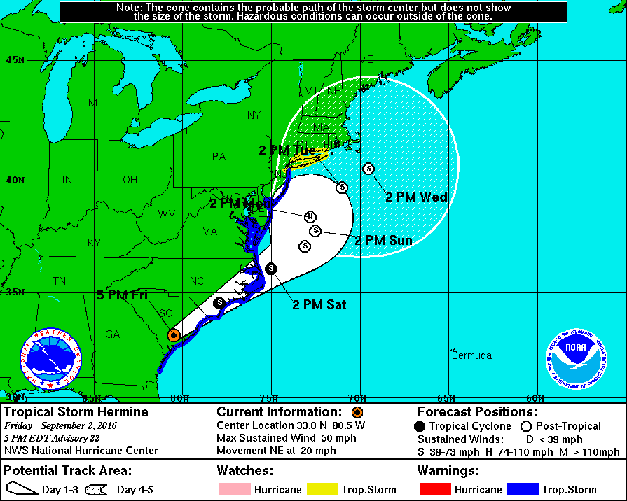
This graphic shows an approximate representation of coastal areas under a hurricane warning (red), hurricane watch (pink), tropical storm warning (blue) and tropical storm watch (yellow). The orange circle indicates the current position of the center of the tropical cyclone. The black line, when selected, and dots show the National Hurricane Center (NHC) forecast track of the center at the times indicated. The dot indicating the forecast center location will be black if the cyclone is forecast to be tropical and will be white with a black outline if the cyclone is forecast to be extratropical. If only an L is displayed, then the system is forecast to be a remnant low. The letter inside the dot indicates the NHC’s forecast intensity for that time:
D: Tropical Depression – wind speed less than 39 MPH
S: Tropical Storm – wind speed between 39 MPH and 73 MPH
H: Hurricane – wind speed between 74 MPH and 110 MPH
M: Major Hurricane – wind speed greater than 110 MPH
The National Weather Service has issued a tropical storm warning for the entire state of Delaware. Deldot has been placing road closed signs near flood prone areas, like Oak Orchard. Transformer boxes are being sandbagged. We are still looking at over ten to twelve foot waves starting Saturday afternoon after the winds kick up. Delaware State Parks are offering refunds for reservations and people already here that want to leave. Tomorrow they will decide if evacuating the campgrounds is necessary. At least one marina on the inland bays has announced boaters must pull all boats out of their marina by tomorrow. One of the most popular predictions is when the tropical storm rolls back over the Atlantic ocean it could pick up warmer water and speed, which will turn back into a hurricane. That has happened before, and honestly we would be better off with a fast moving hurricane than a slow moving storm system (nor’easter). Storm Jonas managed to breach the dunes in six places during one high tide cycle, had it been a couple more tide cycles we would have had some serious damage. Tropical Storm Hermine will start hitting us hard late Friday night, during a new moon, and will last into Labor Day. We will keep you updated as much as possible on the website and Facebook page. Stay safe this weekend and be smart about your surroundings. If you are undecided about whether you should go to the beach, that is easy … Don’t! Watching storms like this sounds fun, but the reality is, it is scary and can be deadly. This is a great app for watching the storm in real time.
Fish On!!
Rich King
Saturday tides at IRI …
| 09/03 | Sat | 04:10 AM | 0.2 L |
| 09/03 | Sat | 10:37 AM | 2.92 H |
| 09/03 | Sat | 04:24 PM | 0.24 L |
| 09/03 | Sat | 10:53 PM | 3.0 H |
NWS ….. Tropical Storm Hermine Update
Last Updated: 9/2/2016, 5:00:00 PM (EDT)
Location: 33.0N 80.5WMovement: NE at 20 mphWind: 50 MPHPressure: 993 MB
Public Advisory
…Center of Hermine passing near Charleston with strong winds
and heavy rain…
…Dangerous storm surge expected in the Hampton Roads area…
Summary of 500 PM EDT…2100 UTC…information
———————————————-
location…33.0n 80.5w
about 30 mi…50 km WNW of Charleston South Carolina
about 55 mi…90 km NNE of Hilton Head Island South Carolina
maximum sustained winds…50 mph…85 km/h
present movement…NE or 55 degrees at 20 mph…31 km/h
minimum central pressure…993 mb…29.33 inches
Watches and warnings
——————–
changes with this advisory:
The Tropical Storm Warning has been extended northward from Fenwick
Island, Delaware, to Sandy Hook, New Jersey, including Delaware Bay.
The Tropical Storm Warning has been discontinued south of Altamaha
Sound, Georgia.
Summary of watches and warnings in effect:
A Tropical Storm Warning is in effect for…
* Altamaha Sound to Sandy Hook
* Pamlico and Albemarle sounds
* Chesapeake Bay from Drum Point southward
* tidal Potomac from Cobb Island eastward
* Delaware Bay
A tropical storm watch is in effect for…
* north of Sandy Hook to west of Watch Hill
Interests elsewhere along the United States northeast coast should
monitor the progress of this system.
A Tropical Storm Warning means that tropical storm conditions are
expected somewhere within the warning area within 36 hours.
For storm information specific to your area, including possible
inland watches and warnings, please monitor products issued by your
local National Weather Service forecast office.
Discussion and 48-hour outlook
——————————
at 500 PM EDT (2100 utc), the center of Tropical Storm Hermine was
located by NOAA Doppler radar and surface observations inland
over southern South Carolina near latitude 33.0 north, longitude
80.5 west. Hermine is moving toward the northeast near 20 mph (31
km/h) and this motion is expected to continue through Sunday with a
gradual decrease in forward speed during that time. On the
forecast track, the center of Hermine will move across coastal
South Carolina this evening, move across coastal North Carolina
tonight and Saturday morning, and move offshore of the North
Carolina coast by Saturday afternoon.
Maximum sustained winds are near 50 mph (85 km/h) with higher gusts.
Little change in strength is expected tonight and early Saturday
while the center of Hermine remains over land. Strengthening is
forecast after the center moves offshore, and Hermine could be near
hurricane intensity by late Sunday.
Tropical-storm-force winds extend outward up to 185 miles (295 km),
mainly to the south and east of the center.
A station at Folly Island, South Carolina, recently reported a
sustained wind of 44 mph (70 km/h) and a gust of 59 mph (94 km/h).
Buoy 41029, located just northeast of Charleston Harbor, recently
reported a sustained wind of 40 mph (65 km/h) and a wind gust of 58
mph (94 km/h).
The estimated minimum central pressure based on surface observations
is 993 mb (29.33 inches).
Hazards affecting land
———————-
wind: tropical storm conditions will continue to spread northward
within the warning area along the Atlantic coast through Saturday
night. Tropical storm conditions are possible in the watch area by
late Sunday or Sunday night.
Storm surge: the combination of a storm surge and the tide will
cause normally dry areas near the coast to be flooded by rising
waters moving inland from the shoreline. There is a danger of
life-threatening inundation during the next 24 hours in the Hampton
Roads area. Persons within this area should take all necessary
actions to protect life and property from rising water. Promptly
follow all instructions, including evacuation orders, from local
officials. There is also the possibility of life-threatening
inundation during the next 48 hours at most coastal locations
between the North Carolina/Virginia border and Bridgeport,
Connecticut.
For a depiction of areas at risk, please see the prototype storm
surge watch/warning graphic, which displays areas that would qualify
for inclusion under a storm surge watch or warning currently under
development by the National Weather Service and planned for
operational use in 2017. The prototype graphic is available at
www.Hurricanes.Gov/graphics_at4.Shtml?Wsurge
The water could reach the following heights above ground if the
peak surge occurs at the time of high tide…
Hampton Roads area…3 to 5 feet
elsewhere from the NC/VA border to Bridgeport, CT…2 to 4 feet
Rainfall: Hermine is expected to produce storm total rainfall
accumulations of 5 to 10 inches with possible isolated maximum
amounts of 15 inches over the southeastern United States and
portions of the lower mid Atlantic from southern and eastern Georgia
into South Carolina and eastern North Carolina. Across southeastern
Virginia and the lower Eastern Shore of Virginia and Maryland, storm
total rainfall amounts of 4 to 8 inches are expected. These rains
may cause life-threatening floods and flash floods. Rainbands south
of Hermine are expected to bring an additional 1 to 3 inches of
rainfall across portions of central and northern Florida. Heavy
rainfall could reach the coastal areas of Delaware and New Jersey
beginning Saturday night.
Tornadoes: a few tornadoes are possible this evening over coastal
areas of North Carolina and northeastern South Carolina.
Comments are closed.